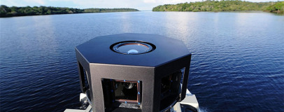
Google has begun a drive to expand its popular Street View project in the Amazon basin in South America.
In a recent blog post, the company reported that it will work in partnership with a charity called Foundation for a Sustainable Amazon (FAS).
As well as using camera-equipped boats that will delve into the many tributaries of the Amazon river, Google will train local people to collect images inland, leaving equipment for the work to continue in the long term.
According to the article, FAS approached Google two years ago with the hope that the visual data obtained from the project would demonstrate the fallout of deforestation and poor global sustainability on the local landscape.
FAS project leader Gabriel Ribenboim said: 'It is very important to show the world not only the environment and the way of life of the traditional population, but to sensitize the world to the challenges of climate change, deforestation and combating poverty.'
The blog post also revealed what it calls a Street View trike - a camera-equipped tricycle
The post stated 'We'll pedal the Street View trike along the narrow dirt paths of the Amazon villages and maneuver it up close to where civilization meets the rainforest'
Google hopes that users will gain new insights and experiences, being able to view the Amazon river and its surroundings as easily as they would any other area documented on Street View.
Street View was launched by Google in 2007, featuring only five cities, but has since grown to include vast swathes of countries such as Australia, the UK, the US, Italy and New Zealand.
What do you make of Street View's focus on the Amazon? Do you think it will aid in solving the issues that surround deforestation and sustainability? Let us know in the forum.

MSI MPG Velox 100R Chassis Review
October 14 2021 | 15:04


Want to comment? Please log in.